Severe Weather Outlook Casts Shadow Over Memorial Day Travel Across Central U.S.
A High-Stakes Forecast for the Heartland
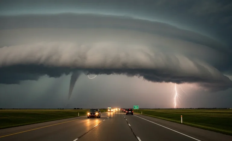
KANSAS CITY, Mo. — In a major development that could reshape the holiday plans of millions of Americans, meteorologists have issued high-risk warnings for severe thunderstorms and potential tornadoes across the Midwest and Central Plains. The timing of this volatile weather system coincides with the Memorial Day weekend, traditionally one of the busiest periods for domestic travel in the United States. As families prepare to hit the roads and take to the skies, federal agencies and weather experts are urging extreme caution, noting that the atmospheric conditions are ripe for significant, long-track tornadoes.
The Storm Prediction Center (SPC) has highlighted a broad corridor of risk extending from the southern Plains into the upper Midwest. Primary concerns include damaging wind gusts exceeding 75 mph, large hail the size of baseballs, and the high probability of tornadic activity. For millions of residents in states such as Kansas, Oklahoma, Missouri, Iowa, and Nebraska, the holiday weekend is shifting from a time of celebration to a period of vigilant monitoring and emergency readiness.
Travel Disruption on a Massive Scale
The intersection of severe weather and peak travel creates a unique set of challenges for public safety. Reports suggest that over 40 million Americans are expected to travel 50 miles or more from home this weekend. The presence of severe supercells across major interstate corridors—including I-70, I-80, and I-35—presents a direct threat to motorists. Expert analysts noted that visibility during these storms can drop to near zero in seconds, and high-profile vehicles are particularly vulnerable to the projected wind speeds.
- Aviation Delays: Major hubs in Chicago, St. Louis, and Dallas are bracing for significant ground stops and flight cancellations as the storm front moves eastward.
- Road Safety: Highway patrols in affected states have increased staffing to manage potential accidents and assist drivers caught in the path of the storms.
- Outdoor Events: Hundreds of Memorial Day parades and community gatherings have already been moved indoors or postponed as a precautionary measure.
The psychological impact of these warnings is also palpable. For many, Memorial Day serves as the unofficial start of summer, but the looming threat of life-threatening weather has forced a recalculation of risk. Transportation officials have advised those with flexible schedules to consider traveling earlier or later than the peak Friday-to-Monday window to avoid the most dangerous windows of atmospheric instability.
Understanding the Atmospheric Conditions
Meteorological analysis indicates that a powerful low-pressure system is drawing significant moisture from the Gulf of Mexico, colliding with a sharp cold front moving in from the Rockies. This collision creates what scientists call “convective available potential energy” (CAPE), which serves as fuel for the development of severe thunderstorms. What makes this particular weekend concerning is the presence of strong wind shear, which provides the rotation necessary for tornado formation.
While the Midwest is no stranger to spring storms, the scale and intensity of this specific system are noteworthy. Reports from the National Weather Service suggest that the atmospheric profile is remarkably similar to historic outbreaks seen in previous decades. Local authorities are stressing that even those outside the “high-risk” bullseye should remain alert, as secondary lines of storms can produce localized flooding and damaging downbursts far from the primary center of activity.
Safety Measures and Emergency Preparedness
In response to the escalating threat, emergency management directors are emphasizing the importance of having multiple ways to receive weather alerts. In an era of digital connectivity, experts warn that relying solely on outdoor sirens is a dangerous mistake, particularly at night when many are asleep. Wireless Emergency Alerts (WEA) on smartphones, NOAA weather radios, and local news applications are considered essential tools for survival.
Key Preparations for Residents:
1. Identify Your Safe Space: Whether it is a basement, a storm cellar, or an interior room on the lowest floor, ensure every family member knows where to go when a warning is issued.
2. The “Go-Bag” Essentials: Keep a kit containing flashlights, batteries, a first-aid kit, and essential medications ready. Experts also recommend wearing sturdy shoes and helmets during a tornado warning to protect against flying debris.
3. Communication Plans: Establish a point of contact outside the immediate area to check in with after the storm passes, as local cellular networks may become overwhelmed.
As the front moves across the central United States, the focus will remain on the protection of life and property. While the economic impact of cancelled events and travel delays is substantial, the priority for officials remains the safety of the public. The next 48 to 72 hours will be critical as the system evolves, requiring a unified effort from meteorologists, emergency responders, and the public to navigate this high-risk period.
Frequently Asked Questions
What regions are at the highest risk this weekend?
The highest risk is currently centered on the Central Plains and the Midwest, specifically covering portions of Kansas, Oklahoma, Missouri, Nebraska, and Iowa. However, the storm system is expected to track eastward, potentially bringing severe weather to the Ohio Valley by the end of the weekend.
How will this affect air travel for Memorial Day?
Travelers should expect significant delays and potential cancellations at major airports in the central U.S. Airlines often issue travel waivers during severe weather events, allowing passengers to rebook flights without penalty. It is recommended to check flight statuses frequently before heading to the airport.
What should I do if a tornado warning is issued while I am driving?
If you are in a vehicle during a tornado warning, the best course of action is to find a sturdy building immediately. If no building is available, do not seek shelter under a highway overpass, as these can create a wind-tunnel effect. As a last resort, park the car, stay buckled, and keep your head below the windows, covering yourself with a blanket or coat.
Is the threat expected to last the entire holiday weekend?
The most intense period of severe weather is forecast for Friday through Sunday. While Monday may see the system begin to weaken or move into the Eastern U.S., residual flooding and debris could still impact travel and outdoor activities on the holiday itself.