JetBlue Strike at 3,000 Feet Ignites Push for Mandatory Drone Geofencing
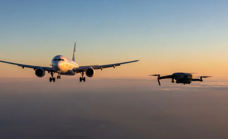
The carbon-fiber props of a consumer drone are no match for the titanium of a jet engine, but at 200 knots, even a two-pound plastic frame becomes a kinetic projectile. This scenario nearly turned tragic over Queens Monday evening as a passenger aircraft battled the hazards of an increasingly crowded low-altitude sky.
A JetBlue passenger flight collided with a drone at an altitude of 3,000 feet while on final approach to land at John F. Kennedy International Airport. The incident occurred during the aircraft’s descent on June 29, 2026, marking one of the highest-altitude drone strikes recorded in the New York City terminal area.
No injuries were reported among the passengers or crew members on board the flight. The aircraft successfully completed its landing at JFK following the impact, though the collision triggered an immediate safety response.
Investigation and Airspace Violations
The Federal Aviation Administration (FAA) and local law enforcement are currently investigating the illegal operation of the drone. The device was operating within restricted airspace where consumer drones are strictly prohibited without specific federal authorization.
JFK Airport operations were briefly impacted as a safety precaution while authorities scanned the approach path for additional debris or hardware. The drone’s operator has not yet been identified or apprehended by New York authorities.
The Surge in Unauthorized Flights
Drone sightings near major U.S. airports have seen a 15% increase in the first half of 2026. This spike comes as consumer drone sales hit record highs, outpacing the implementation of federal tracking and enforcement tools.
- The collision occurred in the Queens borough of New York City.
- Aviation experts are calling for stricter “hard” geofencing technology for all consumer drones sold in the U.S.
- The FAA is reviewing Remote ID data to attempt to trace the drone’s point of origin.
Beyond Software Restrictions
Aviation safety advocates are pushing for a transition from software-based warnings to hardware-level “hard-locks” that prevent motors from spinning within five miles of an airport. Current geofencing can often be bypassed by users installing third-party firmware or disabling GPS modules.
The 3,000-foot altitude of this strike is particularly concerning to safety officials. Most consumer drones have software limits at 400 feet, suggesting the device involved in the JetBlue incident was intentionally modified to reach commercial flight paths.
Related Coverage
Frequently Asked Questions
What is ‘hard’ geofencing for drones?
Hard geofencing refers to hardware-level integration that prevents a drone from taking off or entering specific coordinates. Unlike current software warnings, this would be baked into the flight controller and cannot be easily disabled by the user.
What are the legal penalties for flying a drone near an airport?
Operators can face federal prison time, the permanent loss of pilot privileges, and FAA fines exceeding $30,000 per violation. In cases where a collision occurs, criminal endangerment charges are often applied.
How do airports currently detect unauthorized drones?
Major hubs like JFK use a combination of radar, radio frequency sensors, and optical cameras to spot drones. However, small plastic drones have low radar cross-sections, making them difficult to track until they are in close proximity to aircraft.
Why is 3,000 feet a significant altitude for a drone strike?
Standard FAA regulations limit consumer drones to 400 feet above ground level. A strike at 3,000 feet indicates a deliberate breach of safety protocols and places the drone directly in the path of heavy commercial jets during their most vulnerable flight phase.